I visited Zermatt four times during my four years in Switzerland, not an inconsiderable number given that each time it was a day trip, and it takes over three hours (one way) to travel from Lausanne to Zermatt. I actually did not spend much time in Zermatt itself, because it is something of a Swiss tourist mecca, perhaps only matched by Interlaken, and after six months of living in Switzerland, I stopped feeling like a tourist. Instead, Zermatt was the starting point for three very memorable hikes, and one memorable train ride on the Gornergratbahn with my mom.
To reach Zermatt from Lausanne, you take the InterRegio to Visp (if you are lucky, you can occasionally catch the faster Cisalpino on its way to Milan), then switch to the Matterhorn Gotthard Bahn traveling south to Zermatt. The train climbs up near three-quarters of a mile in altitude (in some places using cogs to handle the incline) as it travels through the Mattertal, finally ending in Zermatt:
 |
| The Matterhorn looms above Zermatt |
Trip #1: August 2007
Two of my good friends visited me in Switzerland, and I suggested we go to Zermatt and see the Matterhorn. The weather in Switzerland, particularly in the mountains, is fickle, so I woke up at 6 am on a Saturday to check the webcam for the Matterhorn. When I saw it was blue skies and no clouds, I roused my friends, we hustled to the train station (stopping for some delicious croissants at a nearby bakery), and away we went.
We were fortunate, for though it was August, the previous week had been rainy and cold, so the mountains above Zermatt were newly dusted with snow. We did a classic hike, starting at Sunnegga (2288 m), an underground funicular ride up from Zermatt, past three lakes -- the Stellisee, Grindjisee, and Gruensee -- to Riffelalp. I have many pictures of the hike, but this is forever my favorite:
 |
| The Matterhorn, reflected in the clear waters of the Stellisee |
Trip #2: August 2009
It would be two years later that I would return to Zermatt. This time, two more friends (both Americans, but living in Lausanne and working at EPFL) joined me. We had decided to tackle the steep climb from Sunnegga to the Unterrothorn, topping out at over 3100 m above sea level. The weather report forecasted early clouds, but by the time we arrived, I hoped they would clear. When we arrived in Zermatt, the clouds hid everything, including the Matterhorn, and we were very disappointed. Nonetheless, we took the funicular up to Sunnegga, hoping we might get above the clouds. Even up there, however, the clouds still obscured everything. We resigned ourselves to finding a shorter, less scenic hike, but as we were studying the map, I turned around and saw this:
Within 30 minutes, the Matterhorn looked like this:
With suddenly blue skies and snow-capped mountains welcoming us, we began the steep ascent to the Unterrothorn, culminating in a rocky, exposed trek along the Ritzengrat:
Finally, we reached the top, and were rewarded with 360 degrees worth of views:
Trip #3: October 2009
In the fall of 2009, my mom visited me in Switzerland. She was very lucky because we had one week of glorious weather, a truly rare feat in Switzerland. Towards the end of her trip, I think she was getting a bit tired with crisscrossing the country (though it is her fault on insisting we go to Liechtenstein), but I told her that the weather was great and she would not forget a trip up into the mountains above Zermatt. This time, we went to Zermatt not for a hike, but to take the Gornergratbahn up to Gornergrat, a station at 3100 m complete with a shopping mall! But the best part of Gornergrat are the views:
Trip #4: July 2010
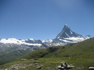
My last visit was a grand hike up to the Hohbalmen, an alpine meadow high above Zermatt, with fantastic views of glaciers and mountains all around. The hike consists of two parts: a traverse up a stream bed called the Triftbach, and then a climb up to the Hohbalmen itself. This hike took me to the other side of the valley, somewhere I had not been before above Zermatt.
 |
| The Triftbach |
 |
| At Trift, below the Gabelhorn Gletscher |
 |
| Hohbalmen, with a view of the Matterhorn |
Like I said, I could do without the town of Zermatt, but it is the launching point for numerous incredible hikes in one of the most picturesque locales in the Swiss Alps. That wraps up the A to Z Blogging Challenge here on Occam's Samurai Sword, I hope you enjoyed it!


No comments:
Post a Comment